

Starting point: near the wooden bridge of Skiparque enterprise.
For the walker lover, the Holm Route is particularly attractive, allowing diversity and depth of consecutives visual sights, conferred by the altitude and the transversal profile of the valleys and the gracious hill tops. The multiplicity of forms, textures and the relief movement, associates diversified and rich vegetation.
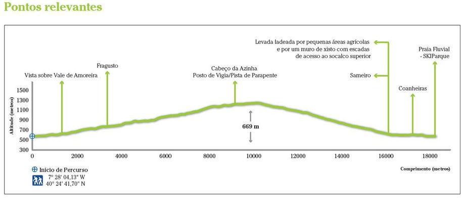
Along the way is possible to contemplate the shaping marks made by Man. Stands out the “Coanheiras” – agricultural fields located near the Sameiro Village, taking advantage from the River Zêzere water, which is conducted in streams, and that includes prairies and horticulture (big beans, beans, potatoes, tomatoes, lettuce, onions, garlic, peas, kale, carrots, etc)… On this spot you can observe the subdivision of the rural parcels and water line, that basically consists in samples of Common Ash, Grey Willow, White Willow, Alder, Poplar.
The highest altitude, the trail crosses the Fragusto Farm – larger farm where is practise a mountain agriculture, based on grazing, rye cultivation and forest, and the Holm-oak Head – natural belvedere that provides an excellent overview for valleys and mountains to lose sight.
The Holm Route allows a visit to the old house of the Forest Guard of “Gorgulhão” – the Forest Guard houses were built in order to promote the Forest Perimeters and its management units, allowing the establishment of Forest Guards and their families which would have to supervise and guard the assigned areas. The Forest Guards have played a key role in the forestation and protection of these Forest Perimeters which occupies the most part of the Mountain. The “Gorgulhão” is still composed by a recreation area that includes a jogging circuit, mountain bike path and a picnic area surrounded by dense coniferous forests.
In terms of flora, we can find species as important as the holm-oak, the rowan, the common ash, the alder, the Pyrenean-oak, the white broom, the heather, the rosemary, the wrack, the cherry, the willk, among others.
The Holm Route landscape is characterized by ecosystems that allow emergence of diversified vegetation, at the same time provides an habitat for a diversified fauna, such as the kingfisher, partridge, montagu’s harrier, common kestrel, jay, wild rabbit, fox, lesser horseshoe bat, fire salamander, boga, etc…
It’s important to refer that the Holm Route allows an interaction with the Amoreira Valley Route, Moors Corridor Route and Sameiro Route.
- Alertas
-
-
Trail PR15 Closed
1 January, 2016
-
- Route PR10MTG
-
- Name: Holm
- Type: Circular
- Coordinates of the beginning W: 7º28'04.13"W 40º24'41.70"N
- Height at the beginning: 574 m
- Minimum height: 574 m
- Maximum height: 1243 m
- Advised direction: Counterclockwise
- Difficulty: Average
- Extension: 18,4 km | 20 km (with leads)
- BTT: Yes
- Useful Documents